Getting Started with Geospatial Data Fusion
This session will provide the necessary foundational knowledge to get started on geospatial data fusion.

Geospatial data fusion has been successfully applied in earth observation and space applications, computer vision, military, and security, as well as in many other areas such as emergency management and medical imaging. For military applications, the intelligence extracted from geospatial data fusion makes it easier for analysts to recognize relevant patterns and identify potential adversaries. But the combination of two or more different datasets is successful if only incorporating data features that are suitable for the intended application. This session will provide the necessary foundational knowledge to get started on geospatial data fusion. Participants will learn from a variety data fusion examples germane to GEOINT, including high-resolution imagery, multispectral imagery, raster, vector, and text data.
Learning Objectives:
After completing this session, the learners will be able to:
- Define the data fusion modeling approach as a geospatial technique
- Explain value proposition and potential applications of geospatial data fusion
- Define the key features of geospatial data fusion
- Identify potential pitfalls associated with data fusion
- Practice using simple examples of geospatial data fusion
Instructors:
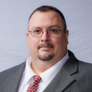
- Talbot Brooks, Director of the Center for Interdisciplinary Geospatial Information Technologies, Delta State University
- Dr. Bradley Matthew Battista, Director of Science and Technology, Battlespace, Inc. & Owner, EnerGeo Solutions, LLC.
Bios:
 Mr. Talbot Brooks is the Director of the Center for Interdisciplinary Geospatial Information Technologies at Delta State University. He led the creation of the first USGIF accredited Bachelor of Science degree in Geospatial Analysis & Intelligence and the first master’s degree program for geospatial technologies accredited as an applied science. Outside of academia, Mr. Brooks has been a career firefighter, volunteer firefighter, medic, and a U.S. Army Reserve Medical Service Corps Captain. He has volunteered his services, time, and effort for significant events and crises such as the April 2011 tornado outbreak in Mississippi, the 2011 Mississippi flood, the 2011 Tohuku Tsunami, the 2010 Haiti earthquake, and Hurricanes Katrina and Rita in 2005, among many others. Mr. Brooks was appointed to the National Geospatial Advisory Committee for 2013-2016 by Secretary of Interior Salazar. Other appointments include President of the Geospatial Information and Technology Association (GITA), Director for the GIS Certification Institute, Chair of the Technical User’s Group for the Mississippi Coordinating Council for Remote Sensing and GIS, and member of the National Fire Protection Agency’s Technical Standards Committee. Mr. Brooks received a M.S. in Plant Biology from Arizona State University and a B.S. in Biology from Rochester Institute of Technology.
 Dr. Bradley Matthew Battista is a marine scientist, geophysicist, and computational geoscientist. He is the Director of Science and Technology at Battlespace, Inc., owner of EnerGeo Solutions, LLC., and Chair of the USGIF Tradecraft and Professional Development Committee. Bradley combines geoscience and information technology into a multidisciplinary career focused on overcoming unconventional geotechnical challenges.


