

The United Stated Geospatial Intelligence Foundation (USGIF), in partnership with sponsors 3GIMBALS and Esri, hosted the inaugural Spatial EDGE Miami on February 18-19, 2025. This new event type was developed in response to feedback from member organizations outside the Washington D.C., metro area.
Spatial Edge events aim to:
- Strengthen the GEOINT community across government, military, industry, and academia within a specific geographic locality–particularly near key end users of GEOINT capabilities.
- Foster insightful discussions on challenges and opportunities that enable the GEOINT community to better support mission success.
Spatial EDGE Miami focused on U.S. Southern Command (SOUTHCOM) missions, which face unique GEOINT challenges due to:
- Historic collection limitations
- Unconventional target sets
- Complex intelligence-sharing policies
The event attracted a diverse audience, including SOUTHCOM military and civilian personnel, students, investors, and industry representatives including CEOs–several of whom traveled from outside the region. Florida International University (FIU) hosted the event, beginning with an introduction by Mr. Bruce Vitor, Director of Research and Operations at the FIU Jack D. Gordon Institute for Public Policy.
He provided an overview of FIU’s public policy program and its research efforts supporting SOUTHCOM in areas such as:
- Transnational organized crime
- Counterterrorism and counter-extremism
- Energy and environmental security
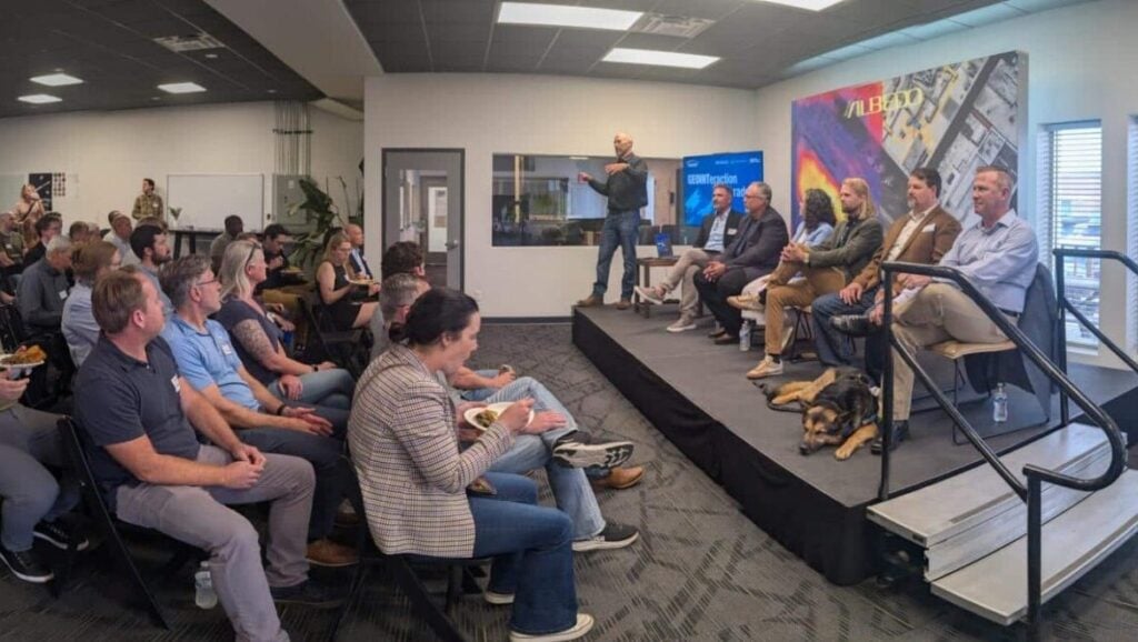
A key takeaway from this discussion was the recognition that academia serves as a force multiplier for commands. Attendees agreed that improved visibility across all academic programs supporting national security missions would benefit the broader GEOINT community. USGIF will explore the possibility of facilitating this visibility. The opening address was followed by a panel discussion focused on how GEOINT data impact SOUTHCOM’s diverse mission.
Panelists included:
- Jose Angeles, Chief Data Officer, SOUTHCOM
- Anthony Deangelo, National Geospatial-Intelligence Agency (NGA) SOUTHCOM
- Michael Barton, DoD Chair for the Defense Criminal and Investigative Enterprise Capability Development, Director of HQ Air Force Office of Special Investigations Mission Integration and Capability Development
- Moderator: Mr. Terry Dyess, Founder and CEO, 3GIMBALS (Premier Sponsor)
Key takeaways from the panel include:
- Enterprise Domain Awareness (EDA): SOUTHCOM’s innovative EDA program prioritizes proactive, unclassified geospatial-enabled data sharing with partner nations to advance U.S. strategic objectives.
- Defining Data and AI/ML Standards: There is a pressing need for a common understanding across organizations regarding definitions of data, automation and AI/ML.
- Enterprise Tools Are a Priority: The adoption of scalable enterprise tools should take precedence.
- Balancing Data Integrity & Mission Needs: Not all missions require the “gold standard” of data verification—some, like human trafficking interventions, demand speed over pristine validation.
- Governance & Policy Over Technology: Policy inconsistencies, rather than technological gaps, remain the primary obstacle to codifying data and AI/ML standards.
- Improving Government-Commercial Integration: The U.S. government must better integrate commercial GEOINT capabilities to reduce latency and increase data persistence
The event concluded with a keynote by Mr. Dan Hilliard, recently retired Chief Data and Artificial Intelligence Officer (CDAO) of U.S. Special Operations Command (SOCOM). He spoke on the transformative potential of AI/ML, high-performance computing, and quantum technologies in reshaping DoD and Intelligence Community capabilities. The inaugural Spatial EDGE Miami successfully convened key GEOINT stakeholders to explore SOUTHCOM’s unique mission requirements and foster collaboration across government, industry, and academia. USGIF will continue refining this event model to strengthen regional GEOINT engagement and drive meaningful dialogue on critical issues.
Related Articles
GEOINTeraction Colorado: Exploring Space-Based Thermal Insights
At USGIF’s June GEOINTeraction Colorado, USGIF’s Front Range Area Community (FRAC) of Interest gathered government and industry leaders for a discussion on spac…

USGIF Welcomes Civil Air Patrol
Herndon, Virginia (July 2, 2026) – The United States Geospatial Intelligence Foundation (USGIF) is pleased to announce Civil Air Patrol (CAP) has joined USGIF a…

Turning Maritime Awareness Into Decision Advantage
At USGIF’s June GEOINTeraction Tuesday, U.S. Coast Guard Assistant Commandant for Intelligence Steven Griffin called for a faster “detect-to-act” approach to ma…